Virginia Grain Locations
The Virginia Department of Consumer Services (VDACS) and USDA’s Agricultural Marketing Service (AMS) collect cash and new crop grain bids for several regional locations throughout the state. VDACS releases daily cash bids for each location as well as monthly average cash and new crop bids. The VDACS locations are as follows:
- Eastern Shore (corn, soybeans, and wheat)
- Harrisonburg (corn, soybeans)
- Middle Peninsula (corn, soybeans, and wheat)
- Norfolk Producer (corn, soybeans)
- Norfolk Terminal (corn, soybeans, and wheat)
- Petersburg (corn, soybeans)
- Richmond (corn, soybeans)
- Roanoke (wheat)
- Wakefield (corn, soybeans, and wheat)
Where should I market my grain? Learn more about basis patterns across cash market locations.
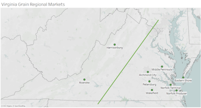
Figure 1 shows the map of nine regional grain locations. Many of the elevators and delivery locations are located on the state’s eastern side to accommodate grain producers. According to the 2017 Census of Agriculture, the three counties in Virginia that produced the most corn in bushels were Accomack County with 2.803 million bushels, Caroline County with 2.181 million bushels, and Essex with 2.174 million bushels. Accomack and Caroline counties also lead in soybean production with 1.205 million bushels and .921 million bushels, respectively, followed by Southampton with .917 million bushels (USDA NASS 2017). Each of these counties are located to the east of the dividing line in figure 1. This data shows the need for the elevators and delivery points to be located on the eastern side of the state to take the burden of transportation off the producers. The locations on the state’s western side are mainly smaller elevators and mills that supply products to end users. Virginia’s largest agricultural sector, the poultry industry contributes about $13 billion annually to the Virginia economy. Much of the poultry industry is centered in the Shenandoah Valley close to processing plants, feed mills, and hatcheries. According to the National Agriculture Statistics Service, Rockingham County has 483 poultry farms, Augusta County has 132, Page County 111, and Shenandoah County 67 (USDA NASS 2017). Virginia’s cattle and calves industry is statewide, however, much of the production is centered in the western part of the state along with the poultry sector. According to the 2017 Census of Agriculture, Virginia’s cattle and calves industry had $462,978,000 in farm cash receipts (USDA ERS 2019). These end users of grain are mostly located to the west of the dividing line in figure 1. With these spatial differences and the Appalachian Mountains separating the state into two halves, it creates locational separation between Virginia’s grain production and consumption regions.
References
USDA ERS. (2019). ERS Annual Report, FY 2017 annual report.
United States Department of Agriculture. 2017 State and County Profiles | 2017 Census of Agriculture | USDA/NASS. Retrieved February 9, 2023.